Kanchenjunga Circuit Trek 18 Days
Not yet rated


Overview
Far from the crowds and deep in Nepal's far eastern frontier, the Kanchenjunga Circuit Trek circles the world's third-highest mountain — 8586 m of raw, glaciated grandeur. This 18 day expedition visits both North Base Camp at Pangpema (5143m) and South Base Camp at Oktang (4580m) in one complete circuit through Nepal's most restricted wilderness zone.
You arrive via the tea gardens of Ilam before tracing the Ghunsa Khola deep into alpine territory. Rhododendron forests give way to glacial moraines and Tibetan-influenced villages to dramatic high passes — Sinion La and Sinelapche La — connecting both flanks of the massif. Two acclimatisation days pace your ascent safely toward Pangpema, where Kanchenjunga and her satellite peaks fill the entire horizon.
Protected by the Kanchenjunga Conservation Area, this circuit rewards seasoned trekkers with something rare: genuine solitude, raw wilderness, and a mountain so vast it commands the sky.
Key Facts
Book Now
Itinerary
Kathmandu - Fikkal Bazaar
Stops in a Day
Description
A short flight from Kathmandu carries you east over the green hills of Nepal, landing at Bhadrapur in under an hour. Our team then drives you north through the Ilam district, the heart of Nepal's tea country. Fikkal and Kanyam sit at 1500m: cool air, rolling hills, and cardamom-scented ridges. A gentle, scenic introduction to the eastern Himalaya awaits.
Fikkal Bazaar - Taplejung
Stops in a Day
Description
The drive to Taplejung winds through terraced farmland, cardamom fields, and Limbu villages draped across the ridgeline. Roads are a mix of sealed and gravel – at times rough, always spectacular. Taplejung is the last proper town before the wilderness begins. Stock up here on snacks, batteries, and SIM cards. Hotel beds and ATMs won't appear again for weeks.
Taplejung - Sekathum
Stops in a Day
Description
The trek officially begins — the trail drops from Taplejung into the Tamor River Valley before following Ghunsa Khola upstream. Suspension bridges, stone steps, and dense subtropical forest mark your entry into the Kanchenjunga Conservation Area. Limbu and Rai villages dot the route, people farming millet and maize on terraced slopes. Sekathum is a small riverside settlement where the real adventure starts.
Sekathum - Amjilosa
Stops in a Day
Description
One of the steeper days of the early trek. The trail climbs persistently through bamboo groves and rhododendron forest, with cliffside sections demanding careful foot placement. Humidity can be high and the path occasionally muddy. Keep your eyes open — langurs, red pandas, and Himalayan monals inhabit this forest zone. Amjilosa is a remote cluster of wooden teahouses nestled deep in the gorge.
Amjilosa - Gyabla
Stops in a Day
Description
A shorter day that lets the body settle into the rhythm of altitude. The trail continues through pine, bamboo, and oak forest — vegetation shifting as elevation increases. Yaks, sheep, and goats become trail companions, and the communities you pass grow increasingly Tibetan in character. A wooden bridge over Ghunsa Khola marks your arrival in the peaceful village of Gyabla.
Gyabla - Ghunsa
Stops in a Day
Description
Passing through Phale — once a Tibetan refugee camp, now a winter settlement — the trail continues toward Ghunsa, the largest community on the circuit. Open pastoral land and forest trails bring the Himalayan peaks progressively into view. Ghunsa has a police post, a health post, a phone signal, and a monastery worth visiting tonight. Rest well—the altitude climbs sharply from here.
Ghunsa (Acclimatization Day)
Stops in a Day
Description
Today is yours to breathe, explore, and prepare. Our guide leads an acclimatisation hike up the ridge above Ghunsa – a five-hour round trip rewarding you with sweeping views of Jannu (Kumbhakarna), one of the most dramatic peaks in the eastern Himalaya. The principle is simple: climb high, sleep low. Use today wisely—tomorrow the trail pushes toward 4100 m.
Ghunsa - Kambachen
Stops in a Day
Description
Jannu Himal dominates the skyline as the trail ascends through a green glacier valley. Blue sheep and snow leopards inhabit this remote corridor — sightings are rare but never impossible. Past a dramatic waterfall and through a steep boulder zone, the trail opens onto Kambachen at 4100m. A handful of teahouses, extraordinary mountain views, and the clean, cold air of high-altitude Nepal.
Kambachen (Acclimatization Day)
Stops in a Day
Description
A second strategic rest day — this time at 4100m with Pangpema in your sights. Our guide leads a neighbouring ridge hike where Kanchenjunga's north face reveals itself in full. The vista from the top is one of the finest panoramas on the entire circuit. Come down slowly, eat well, hydrate, and and rest. Tomorrow, you cross the 4500m threshold for the first time.
Kambachen - Lhonak
Stops in a Day
Description
The trail today traverses moraine from the Kanchenjunga Glacier – a vast lunar landscape of ice-carved rock and boulders under open sky. No settlements exist on this stretch, only summer yak pastures and the ever-present possibility of a snow leopard. Lhonak sits at 4785m in a barren, windswept valley. The scenery is stark, the air is thin, and the remoteness is absolute.
Lhonak - Return Back To Lhonak
Stops in a Day
Description
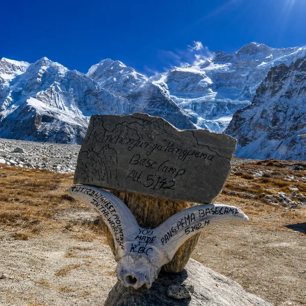
The highest point of the entire circuit. From Lhonak, the trail climbs to Pangpema at 5143m — Kanchenjunga North Base Camp — where Kanchenjunga, Tent Peak, Nepal Peak, and Chang Himal tower above you in glaciated glory. No teahouses exist here, only rock, ice, and altitude. We return to Lhonak the same day — tired, exhilarated, and genuinely changed.
Lhonak - Ghunsa
Stops in a Day
Description
A long descent retracing the moraine trail through Kambachen and Ramtang back to Ghunsa. Dropping nearly 1200m in a single day, the landscape softens from barren alpine to lush green forest with every hour. Legs are tired, but lungs welcome the thickening air. Ghunsa feels almost luxurious — a warm meal, a monastery, and the knowledge that the southern circuit begins tomorrow.
Ghunsa - Sele Le
Stops in a Day
Description
Leaving Ghunsa, the trail climbs through forest and along an open grassy ridge with sweeping views back toward Ghunsa and Phole villages. In the far distance, the outline of Makalu — Nepal's fifth-highest peak — appears on the horizon. Sele Le sits at 4390m and marks the transition between the northern and southern flanks of the Kanchenjunga massif. Big views, cold stars.
Sele Le - Cheram
Stops in a Day
Description
The most demanding day of the southern circuit. Crossing Sinion La (4450m) and ascending to Sinelapche La (4830m), the trail rewards every step with panoramic views of Kanchenjunga and the Yalung Glacier below. A long descending ridge walk brings you to Cheram at 3870 m — the only settlement on this remote southern approach: one teahouse, one valley, and a mountain filling the sky.
Cheram - Ramche
Stops in a Day
Description
From Cheram, the trail climbs past Ramche to reach Kanchenjunga South Base Camp — Oktang — a sacred glacier-edge viewpoint draped in Tibetan prayer flags. The south face of Kanchenjunga stands directly above you, immense and silent. One of the most profound mountain moments Nepal can offer. We descend to overnight at Ramche (4580m) to overnight, carrying the memory of something truly rare.
Ramche - Torongding
Stops in a Day
Description
A steep descent from the alpine zone back into temperate forest – rhododendron, pine, and birdsong replacing the silence of the high camps. The Kanchenjunga Conservation Area enfolds the trail as it switchbacks downward through dense canopy. Himalayan monals, barking deer, and red pandas may appear on the way. Torongding is a quiet settlement with minimal amenities. Sleep comes easily here.
Torongding - Rani Pul
Stops in a Day
Description
The final trekking day is a long descent through subtropical forest, bamboo groves, and cardamom plantations. Limbu and Chhetri villages line the route — terraced farms, mud houses, livestock in the fields. Leeches are common in this lower zone, particularly after rain, so gaiters are recommended. Rani Pul is a small roadside settlement where jeep access and connectivity quietly return.
Rani Pul - Kathmandu
Stops in a Day
Description
A local 4WD carries you from Rani Pul along the Kabeli River to Taplejung — the official endpoint of the circuit. Nepal's eastern foothills unfold through the windows: cardamom fields, tea estates, Himalayan ridges softening to green plains. From Bhadrapur, a short flight returns you to Kathmandu. The circuit is complete — 8586m circled, two base camps visited, one extraordinary journey lived.
Things Included
Support Team
- Licensed English speaking trekking guide for all 18 days
- Assistant guide for groups of 6 or more
Permits
- Kanchenjunga Conservation Area Permit (KCAP)
- Restricted Area Permit (RAP)
Pickup and Drop Service
- Airport pickup and drop in Kathmandu
- All local transport transfers as per itinerary including Bhadrapur to Taplejung and Rani Pul to Bhadrapur
Travel Insurance
- Comprehensive guide and porter insurance covering high altitude rescue
- Emergency evacuation
Accommodation
- 17 nights in mountain teahouses on circuit
- 1 night in Kathmandu hotel on return
Transport
- Kathmandu to Bhadrapur and Bhadrapur to Kathmandu domestic flights
- All local jeep and bus transfers as specified in itinerary
Food
- 17 breakfasts, 18 lunches, and 17 dinners throughout the expedition from Day 1 through Day 18
Additional Perks
- Trek completion certificate from Travories
- Welcome orientation in Kathmandu
Things Excluded
General
- Any extra nights in hotels or teahouses arising from flight delays, eather holds, or personal choice
- Any transport not specified in itinerary, emergency evacuation transport arranged independently
Things To Pack
Clothing and Backpack
- Moisture wicking base layer top and bottom (merino or synthetic)
- Thermal mid layer fleece or softshell jacket
Footwear
- Waterproof ankle support trekking boots (broken in before departure)
- Lightweight sandals or camp shoes for teahouse evenings
Toiletries and Personal Items
- Biodegradable soap, shampoo, and body wash
- Toilet paper and hand sanitiser
Gadgets and Extras
- Headlamp with extra batteries (essential for early starts and power outages)
- Power bank minimum 20000 mAh capacity
Optional but Useful
- Lightweight sleeping bag liner for added warmth in basic teahouses
- Compact binoculars for wildlife spotting in the Conservation Area
What Not to Carry
- Heavy hardcover books or bulky reading material
- More than 2 pairs of casual or town clothing